A
fresh set of satellite images released by the Indian Space Research Organization (ISRO) shows the presence of two huge cloud systems over the nation’s coasts that have brought heavy rains to India. One cloud system is present over the Arabian Sea, bringing rains to the Konkan coast of Maharashtra, while the other is over the Bay of Bengal, soaking West Bengal and neighboring regions.
These pictures, captured by the ISRO satellite INSAT-3DR, indicate that the cloud formations associated with both storms extend over their respective regions. The infrared pictures indicate that both cloud systems have very cold tops and are very bright white, indicating intense convection and thunderstorms that can cause heavy to very heavy rain.
Another special weather pattern was noticed by the meteorological department. Over the western part of India, it develops over the coastal area of the Maharashtra state. This type of special weather pattern will occur and travel from the east-central part of the Arabian Sea to reach the Konkan coast. It collects energy from seawater and the SW monsoon and produces very heavy to heavy rainfall in a few parts of Konkan and Goa; however, heavy to very heavy rainfall occurs over Madhya Maharashtra, Saurashtra, Kutch, and Gujarat. IMD predicts the statewide widespread rainfall occurs over Gujarat, Konkan and Goa, and Madhya Maharashtra the first week of July.
To the east of the country, a second dense layer of cloud cover has developed over the northern part of the Bay of Bengal region, covering coastal Odisha, Gangetic West Bengal, and Bangladesh, with thunderstorm clusters indicating very heavy rainfall.
This system is developing with the help of plentiful moisture from the Bay of Bengal region along with favorable upper air conditions that have helped in forming clouds into cumulonimbus clouds. According to the latest report issued by the IMD on July 4, there had been formation of a low-pressure area over the northwestern Bay of Bengal region, and there would be an active monsoon over central India for the coming four to five days.
Due to the progress of this weather phenomenon further inland, there will be precipitation in West Bengal, Jharkhand, Bihar, and some parts of the eastern states of India, with heavy rains in Gangetic West Bengal and Odisha on July 5 and 6.
The simultaneous formation of active monsoon weather systems on two coasts is because of the geographical nature of India’s monsoon.
There are two streams of the southwest monsoon that obtain moisture from different sources:
- Arabian Sea branch of the Southwest Monsoon, which travels through the western coast of India.
- Bay of Bengal branch of the Southwest Monsoon, which moves from east and northeast regions.
When both branches strengthen at the same time, as they have this week, the result is exactly what ISRO's satellite has captured: two independent but simultaneous convective systems soaking opposite ends of the country.
Upon analyzing the IMD prediction that is given with the help of the image of the satellite data, it can be said that there are certain regions that are likely to have bad weather for the next few days:
- West India: Regions such as Konkan & Goa, Madhya Maharashtra, Saurashtra & Kutch, and Gujarat are expected to receive heavy to very heavy rainfall, and certain regions would also receive extremely heavy rainfall.
- East India: Regions such as Gangetic West Bengal and Odisha would receive isolated very heavy rains, and the regions of Jharkhand & Bihar would be affected by the system.
- Northeast India: There will be extensive or fairly extensive rainfall in regions such as Nagaland, Manipur, Mizoram, and Tripura; however, there will be isolated or scattered showers in regions such as Arunachal Pradesh, Assam, and Meghalaya.
- Other affected regions: These include Bihar, Coastal Andhra Pradesh, Delhi NCR, Punjab, Telangana, and Uttar Pradesh.
There is a meteorological satellite called INSAT of the ISRO satellite group, which was launched in the year 2016. The satellite has the capacity for multispectral imaging, which can study the atmosphere by taking images in six different wavelength regions.
This satellite is useful in tracking cloud formations, convection strength, and storm movements. Information gathered by the INSAT-3DR satellite aids in short-term and long-term forecasting by IMD.
The confirmation of two independent sources via satellites will provide an understanding of the importance of satellite monitoring in India, which relies on monsoons for its agriculture and water resources.
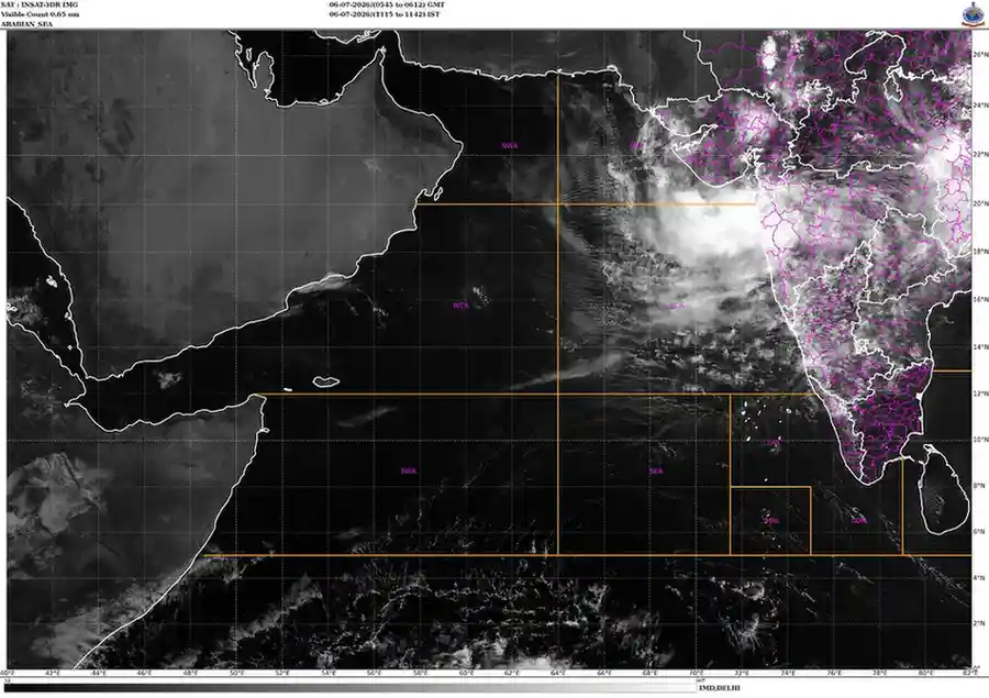
Photo: @ISRO